The Big Pathwatch Survey Results Are In!

bigpatwhwatch

Over a six-month period starting in July last year, walkers up and down the country have reported on what they found when using our extensive network of public rights of way. These results have come in from walkers who took part in the Big Pathwatch which was run by the national Ramblers organisation.

Here in Norfolk, some 1,800 kilometres of paths were walked, and reports made covering 3,600 square kilometres of town and countryside. We are really grateful to everyone who has assisted with the Pathwatch project as it gives an overview of the situation that we have now.

Walkers were asked to report what they found – good, bad and indifferent. 827 positive reports were made, of attractive views (251 reports, almost two thirds of which were of open country), sightings of flora and fauna (90 reports, a quarter of them birds and another quarter trees), as well as interesting buildings, lakes and other natural features (a further 76 reports). 245 reports were also made of welcoming signs, helping walkers find their way.

norfolkresults

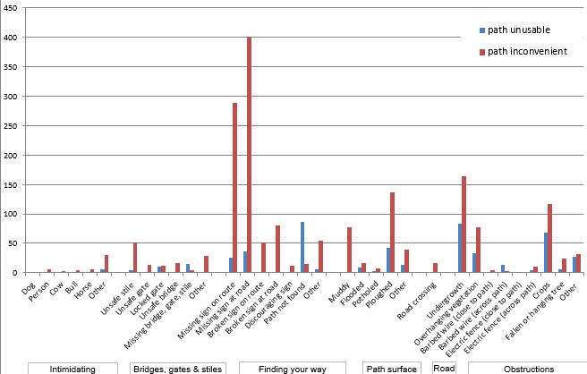
Unfortunately, there was some bad news as well which can be seen on the above chart. 2316 reports were made of unwelcome features and difficulties and this represents nearly three quarters of the reports made, compared to a national average of only 54% of reports being of poor features.

The largest causes of concern were missing signs, either where the right of way left a road (289 reports), or along the route (400 reports). In almost 1 in 10 of these reports, the walker said that this made the route unusable rather than just inconvenient.

The next biggest issues were ploughing across the path (137 reports), crops across the path (117 reports) and overhanging or surface vegetation (241 reports). Again, in approximately a third of these cases, the walker said that this made the route unusable rather than just inconvenient.

We have been reporting this information to Norfolk County Council as the survey has gone on, and we know that officers have looked into the difficulties reported. We are unable to say just what action may have been taken, but we are particularly concerned at the lack of enforcement action being taken when reports are made about paths being ploughed or cropped over, and not reinstated within the legally required timescales. Whilst appreciating the difficulties that the Council faces in taking enforcement action, we – and they – are well aware that they have a legal duty to pursue such action, which includes the ability to recover their costs in doing so.

The Ramblers nationally plans to continue to monitor the state of our public rights of way, as we will do here in Norfolk, and will be pressing the County to make significant improvements this year.

New Area Committee Announced after Area AGM in Sheringham

rpmay
Richard P May

Following the Norfolk Area AGM on Saturday 27 February a new area committee has been elected.

The new area chairman is Richard May who is also currently a national trustee. Richard paid tribute to the work of Bernard Moore, the retiring chairman, and said:

“Bernard has been area chair in Norfolk for as long as I have been a member of Ramblers, and I would like to thank him personally for all the work that he has put in for the Ramblers in Norfolk. He has done a great job on behalf of Norfolk for many years, and he will be a hard act to follow”.

Richard added:

“I look forward to working with the area council members and the wider membership in Norfolk to continue to keep Ramblers an organisation relevant to the 21st century walker, and hopefully to turn the corner on membership levels and start to grow our membership again”.

20160227_154136
Peter (Treasurer), Bernard (outgoing Chairman) and Ken (Secretary)

The area AGM was held in Upper Sheringham and the Sheringham group offered an excellent welcome with biscuits and wonderful home baked cakes.

We also had an interesting talk from Paul Strong, the Head of Ramblers ICT, who also offered an overview of the meeting. Members were able to get an insight into the complex nature of the operations of the national organisation and see the hard work which under-pinned the Big Pathwatch scheme.

After the formal part of the meeting we were also given a wonderfully entertaining talk by Richard Edwards from Sheringham Coastwatch. More information about this voluntary organisation is available at http://www.sheringhamcoastwatch.org.uk/.

imageedit_1_6390310611
Richard Edwards from Sheringham Coastwatch

The new committee is:

Chairman : Richard May

Vice-Chairman : Ian Mitchell

Treasurer : Peter James

Secretary : Ken Hawkins

Footpath Co-ordinator : Ian Mitchell

Press and Publicity : Julian White

Publications Manager : Peter James

Newsletter Co-ordinator : Richard May

Membership Secretary : Derek Goddard


Changes to Norfolk Rights of Way During 2014-2016

ramblers

Ian Mitchell, the area footpath co-ordinator, has compiled a list of all of the changes to the Norfolk Rights of Way over the last two years.

The complete list is available to view at the below PDF file:

Changes to Norfolk Rights of Way during 2014-2016.

For anyone who encounters a path problem in Norfolk, where sure of your details, this can be reported directly to:

Rights of Way Team, Planning & Transportation Dept, Norfolk County Council, County Hall, Martineau Lane, Norwich, NR1 2SG. (Telephone: 0344 800 8020.)

You can also report them online via the map at http://maps.norfolk.gov.uk/highways/ – find the path, click on it,
and follow the instructions.

If unsure, or the problem is not clear, report the problem to Ian Mitchell at ianmitchell5@virginmedia.com. Ian would also like to know anything directly reported to the Rights of Way Team.

Three Rivers Way Association Project to Connect Norfolk Broads

6363738

The first stage of a new project to link local villages in the Broads together using footpaths and cycle tracks has been announced. The work will begin with a track which will connect Hoveton and Horning.

The track will be suitable for both walkers and cyclists with the Hoveton to Horning stretch being around 3.7 kilometres in length. The project is being run by the Three Rivers Way Association and they confirmed that:

“The route will start at Hoveton and Wroxham Station and will have a spur up the Stalham Road to enable pupils to access Broadland High School from the back of the school. The route follows the road to Horning and includes a crossing to St John’s Primary School. Phase 1 finishes at Lower Street Horning”.

After the first stage is completed it is hoped that additional stages will also be opened. These are expected to include Horning to Ludham Bridge, Ludham Bridge to Ludham and Ludham to Potter Heigham.

Further information about the project, which is welcomed by Norfolk Ramblers, is available at http://www.threeriversway.org.uk/.